
Spital am Pyhrn
Spital am Pyhrn | |
|---|---|
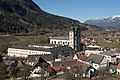
 West view of Spital am Pyhrn | |
 Coat of arms | |
 Spital am Pyhrn Location within Austria | |
| Coordinates: 47°39′55″N 14°20′27″E / 47.66528°N 14.34083°E | |
| Country | Austria |
| State | Upper Austria |
| District | Kirchdorf an der Krems |
| Government | |
| • Mayor | Aegidius Exenberger (SPÖ) |
| Area | |
• Total | 108.89 km2 (42.04 sq mi) |
| Elevation | 640 m (2,100 ft) |
| Population (2018-01-01)[2] | |
• Total | 2,238 |
| • Density | 21/km2 (53/sq mi) |
| Time zone | UTC+1 (CET) |
| • Summer (DST) | UTC+2 (CEST) |
| Postal code | 4582 |
| Area code | 07563 |
| Vehicle registration | KI |
| Website | www.spital-pyhrn.at |
Spital am Pyhrn is a municipality in the district of Kirchdorf an der Krems in the Austrian state of Upper Austria.
Geography
[edit]Spital lies in the Traunviertel. About 48 percent of the municipality is forest, and 19 percent is farmland.
-
 View from Pacherkogel
 -
 Former monastery in winter
 -
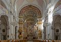 In the parish church
 -
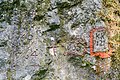 Engravings on rocks
 -
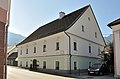 Former mansion of forgery
 -
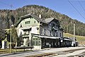 Railway station
 -
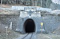 Northportal of railway tunnel Bosruck
 -
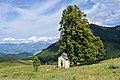 Chapel Ochsenwald
 -
 Arlingsattel - mountain pass
 -
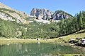 Lake Brunnsteiner
 -
 Alpine pasture Schmiedalm
 -
 Dr. Vogelgesang Gorge


.JPG)
References
[edit]- ^ "Dauersiedlungsraum der Gemeinden Politischen Bezirke und Bundesländer - Gebietsstand 1.1.2018". Statistics Austria. Retrieved 10 March 2019.
- ^ "Einwohnerzahl 1.1.2018 nach Gemeinden mit Status, Gebietsstand 1.1.2018". Statistics Austria. Retrieved 9 March 2019.
Wikimedia Commons has media related to Spital am Pyhrn.
| International | |
|---|---|
| National | |
This Upper Austria location article is a stub. You can help Wikipedia by expanding it. |