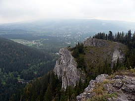
Nosal
| Nosal | |
|---|---|
 | |
| Highest point | |
| Elevation | 1,206 m (3,957 ft) |
| Coordinates | 49°16′35″N 19°59′22″E / 49.27639°N 19.98944°E |
| Geography | |
| Location | Poland |
| Parent range | Western Tatras |
Nosal (lit. 'The Nose') is a mountain in the Tatra Mountains of Poland, and is 1,206 metres AMSL at its highest. It is a popular tourist destination located near the Polish town of Zakopane, particularly for skiing and gliding.[1]
References[edit]
- ^ Mark Baker; Marc Di Duca; Tim Richards (1 March 2016). Lonely Planet Poland. Lonely Planet Publications. p. 499. ISBN 978-1-76034-120-6.
External links[edit]
Wikimedia Commons has media related to Nosal.
